Skip to main content
Shop
Donate
UA Directory
Intranet
Quick Links
Geophysical Institute
Main navigation
Home
About
Contact Information
Contact
UAF Directory
Visitor Information
About the GI
Diversity & Inclusion
GI Publications
Timeline
GI Quarterly
People
Leadership
Researchers
Graduate Student Researchers
Emeriti
Research
Atmospheric Sciences
Remote Sensing
Seismology & Geodesy
Snow, Ice & Permafrost
Space Physics & Aeronomy
Tectonics & Sedimentation
Volcanology
Facilities & Labs
Services
Design & Printing
GI Human Resources
Education Outreach
Instrument Development
Keith B. Mather Library
Research Computing Systems
News & Info
News
Alaska Science Forum
Alaska Science Pod
Science for Alaska
Aurora Forecast
Visitor Information & Tours
Events
Diversity & Inclusion
Student Info
Intranet
Search
News
Breadcrumb
Home
/
News
Filter By Year
- Any -
2024
2023
2022
2021
2020
2019
2018
2017
2016
2015
2014
2013
2012
2011
2010
Solar storm – not HAARP – creates intense auroral display
Geophysical Institute
May 13, 2024
Night skies over the weekend erupted with vivid colors and awed people all around the globe as the solar wind from a severe geomagnetic storm...
Read more
UAF scientist’s research answers big question about our system’s largest planet
Geophysical Institute
May 3, 2024
New discoveries about Jupiter could lead to a better understanding of Earth’s own space environment and influence a long-running scientific...
Read more
Alaska high school students present research at seismology conference
Geophysical Institute
May 1, 2024
Radiation monitoring. Sea ice changes. Floodwater alerts. Coastal erosion. Speeding drivers. Landslide warnings. Thawing permafrost. Weather...
Read more
Seismologists get close-up look at hazardous Barry Arm landslide
Geophysical Institute
April 29, 2024
A high point for about 300 seismologists, geologists and other scientists gathering in Anchorage for a weeklong conference came Monday, April 29...
Read more
UAF researchers use drones to test new instrument for measuring sea ice thickness and its snow cover
Geophysical Institute
April 29, 2024
BEAUFORT SEA ICE, near Utqiagvik, Alaska — The train of 10 snowmachines snaked slowly across the snow-covered sea ice toward the small tent far...
Read more
UAF researchers head to Anchorage for nation’s largest seismology conference
Geophysical Institute
April 25, 2024
University of Alaska Fairbanks seismologists, staff and students will be in Anchorage next week for the annual national meeting of the...
Read more
NSF director: 'I am grateful to UAF’s partnership'
Geophysical Institute
April 24, 2024
Dr. Sethuraman Panchanathan became the 15th director of the National Science Foundation in June 2020 when the U.S. Senate confirmed his...
Read more
SALVO: Studying how snow melts on tundra and sea ice
Geophysical Institute
April 20, 2024
The five University of Alaska Fairbanks researchers didn’t mind the constant wind that gusted to about 30 mph across the flat whiteness on...
Read more
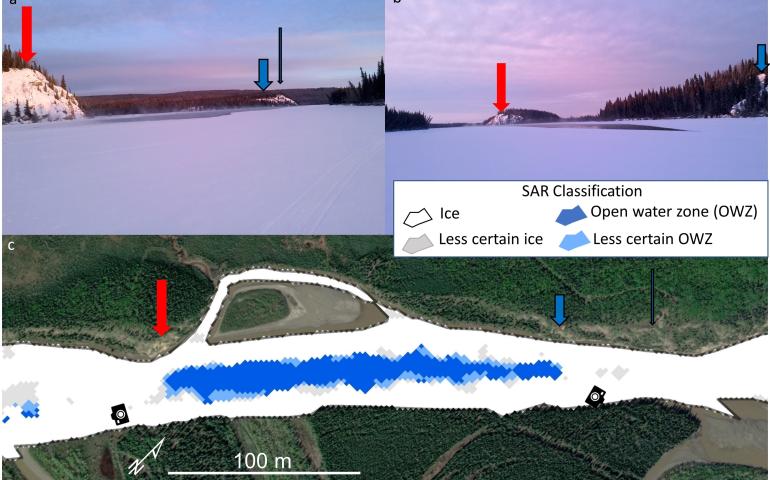
New radar analysis method can improve winter river safety
Geophysical Institute
April 12, 2024
University of Alaska Fairbanks researchers have developed a way to use radar to detect open water zones and other changes in Alaska’s frozen...
Read more
Load More