Fixing the Fatal Flaw of Fairbanks
Natural hazards were not on the minds of Alaska pioneers who hacked homesites out of the wilderness that would later become Anchorage, Valdez, and Fairbanks, but each city has a fatal flaw. Much of Anchorage sits on soils that are unstable when shaken during an earthquake. The same problem forced Valdez to move from the floodplain of the Lowe River to a bedrock townsite after the 1964 earthquake.
The Army Corps of Engineers was able to take much of the risk out of Fairbanks’ most obvious danger—the flooding of the Chena River.
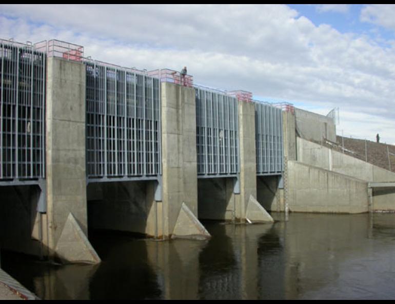
The Chena River Lakes Flood Control Project allows managers from the Corps of Engineers to impound water from the Chena during periods of high flow and shunt it toward the Tanana River. Manhattan could fit inside the 20,000-acre flood control complex in North Pole, which has saved Fairbanks from flooding several times. Since the 1979 completion of the Moose Creek dam, the Tanana River levee, and the four 30-ton floodgates that make up the flood control project, Corps of Engineers personnel have restricted the flow of the Chena 18 times, most recently in early September 2003.
John Schaake, the manager of the flood control project, recently gave me a tour of the extensive grounds on a sunny September day.
The Chena River was high when I visited, but not high enough for Schaake to lower four 30-ton steel gates into the Chena and cut off some of the water bound for Fairbanks, about 40 river miles below the dam. The goal of Schaake and other project personnel is to make sure the river doesn’t flood Fairbanks. The flood in August of 1967 turned the city core into a five-mile wide lake, causing more than $180 million in damage. Congress took notice of the Chena’s destructive effects on Fairbanks and Fort Wainwright and authorized the construction of the $256 million flood control project. Engineers selected a site between North Pole and Eielson Air Force Base where the Chena meanders within about 8 miles of the Tanana River.
The 50-foot rock-filled embankment of the Moose Creek Dam extends about eight miles from the floodgates to the Tanana River, marking the boundary of a floodplain channel that is a dry, green grassland until high water forces Schaake and others to lower the flood gates and divert some of the Chena toward the Tanana.
Because the complex can hold so much water (equivalent to 224,000 football fields covered with one foot of water), Chena River water has only reached the Tanana once in the history of the flood control project. In June 1992, a cold spring conspired with a high snow year to send a giant pulse of water into the upper Chena when temperatures soared. All that snowmelt caused the third highest recorded flow in the Chena, behind 1967 and a flood in 1948.
“A lot of people questioned whether the dam would really protect Fairbanks from big floods before then, but it worked exactly as planned and designed,” Schaake said.
Though many people in Fairbanks are not aware of the massive engineering project 40 miles upriver, it saved the city from catastrophe as recently as July 2003, when more than three inches of rain, one-third of Fairbanks’ annual precipitation, fell on July 26th and 27th. Schaake and his colleagues skimmed water off the Chena for 56 hours, cutting half the river’s flow and preventing the equivalent of 14,000 football fields of water flooded to a depth of one foot from reaching Fairbanks.
“That flood would have put several feet of water into downtown Fairbanks,” Schaake said.
Since contractors finished the flood control project in 1979, it has saved more money in damage to Fairbanks homes and businesses than the one-quarter billion spent on its construction, Schaake said.


