
Lituya Bay's Deadliest Hazard
Lituya Bay in southeast Alaska is famous for a giant wave that swept the bay in 1958, but throughout history another hazard there has proven more fatal.
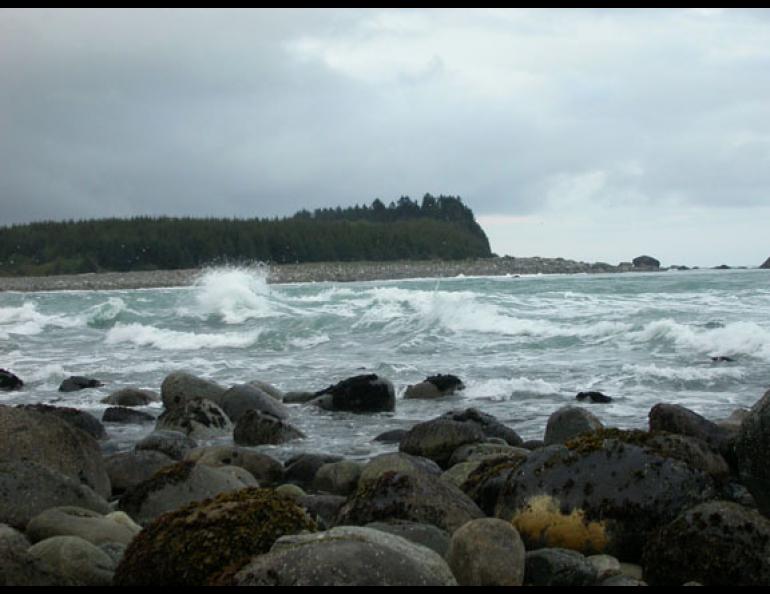
The pull of the moon and the sun drive Lituya Bay’s most deadly feature: a tidal current that scours the narrow mouth of the bay. Lituya Bay is located on the Gulf of Alaska coast about 120 miles northwest of Juneau and 100 miles southeast of Yakutat. I recently visited the bay on a trip to make GPS measurements with a group of scientists.
We hiked to the mouth of the bay one afternoon to view the current. During the middle of low tide, waves broke in all directions at the narrow mouth of the bay. As we looked out to the Pacific Ocean, we saw a lane of breaking waves extending from the bay for a half-mile or more.
Lituya Bay lies perpendicular to the Pacific Ocean coastline, is about seven miles long and varies from three-fourths of a mile to two miles wide. The entrance to the bay is about 1,000 feet across at low tide, and the bay’s tidal fluctuations create a strong current at the entrance recorded to be as fast as 13.8 miles per hour (12 knots), about twice the speed of the Yukon River at Eagle, Alaska. Fishermen and other boaters who enter Lituya Bay do so at slack tide, the minutes at the turn of the tide when the current is slowest.
The entrance to Lituya Bay has claimed numerous ships and lives, many of which are not recorded in history books because they predate the 1786 arrival of French explorer Jean-François de Galaup, Count de La Pérouse. La Pérouse left behind great details of his expedition in his journals, which author John Dunmore later translated and edited. La Pérouse documented the tragedy of his 1786 Lituya Bay expedition, and also wrote about Tlingit canoes lost at the bay entrance shortly before his arrival.
“We learned that seven very large canoes had lately been lost in this passage, while an eighth escaped,” La Pérouse wrote. “These Indians seemed to have considerable dread of the passage, and never ventured to approach it, unless at the slack water of flood or ebb.”
La Pérouse had named Lituya Bay “Port of France,” as he claimed it as his country’s base. He left the bay in a mournful state a few weeks later, after 21 of his men died at the bay’s entrance.
From his command post on an island inside the bay on July 13, 1786, La Pérouse dispatched three small boats and a few dozen men on a mission to hunt for birds and map the depths of the bay close to its entrance. La Pérouse told the commander of each boat to stay away from the entrance if they saw breakers.
Breaking waves were stacked at the entrance to the bay when the three boats drew near, and the oarsmen shouted to one another that it was too dangerous to approach. At the same time, a few crewmen noticed that trees and rocks along the shoreline seemed to be moving with “extreme velocity,” as a survivor later wrote. The tidal current was pulling the boats into the bay’s frothy entrance.
The oarsmen on one boat pulled hard enough to escape the grip of the current, but two boats were soon in the maelstrom at the mouth of the bay. Waves swamped the boats, and all 21 crewmen died.
The survivors searched for bodies on the rocky Pacific shoreline, as did Tlingits from a bayside village, but neither group found any remains. After traveling to Alaska from Europe “without having had a single person sick,” La Pérouse left the bay as soon as possible after the tragedy.
“Nothing remained for us but to quit with speed a country that had proved so fatal,” La Pérouse wrote.


