Two Kinds of Infrared
Most people equate "infrared" with "heat". They may then assume that infrared photographs always reveal temperatures. To understand why this is not always true, we need to go back to the discovery of the infrared portion of the spectrum.
Infrared radiation was discovered early in the nineteenth century by Sir William Herschel, an English astronomer. He was trying to measure the difference in heating power in different parts of the solar spectrum, and found to his surprise that the warmest part of the spectrum was in an area where there was no visible light at all, beyond the red end of the rainbow. He called this invisible light "infrared", meaning within or below the red.
Unfortunately, when James Clerk Maxwell developed his electromagnetic theory, which stated that light and radio waves were both electromagnetic waves, but with different wavelengths, the term infrared was taken over to cover the entire portion of the spectrum between seven tenths of a micrometer (the boundary with red light) and the shortest radio waves (around 1000 micrometers). (It takes roughly 25,000 micrometers to make an inch.) This causes some problems, because different wavelengths of infrared have different sources and behave differently here on earth.
The part of the infrared range which is closest to the visible light spectrum is often referred to as the near infrared. As Herschel discovered, the sun puts out lots of energy in the near infrared, as well as in the visible wavelengths. What surprises many people is that objects at quite ordinary temperatures emit infrared radiation also, but at much longer wavelengths. A snow surface at 0°F has the peak of its emission around 11 micrometers. The warmer the object, the more energy it puts out, at any wavelength. But the intensity of the energy falls off with distance. The sun is so far away that for wavelengths longer than about 4 micrometers, objects on the earth emit more radiation than they reflect from the sun. In these longer wavelengths, known as the thermal infrared, an infrared image does record temperature differences. But an ordinary camera cannot take photographs in these wavelengths, because ordinary glass lenses are opaque in the thermal infrared. In fact, they are not only opaque, but glowing! (For that matter, so is the whole inside of the camera.)
So what do infrared pictures show? The type made with a camera in daylight are recording reflected sunlight, but at longer wavelengths (about seven tenths to nine tenths of a micrometer) than we can see. Aerial photos which show red vegetation are of this type -- near infrared light is printed as red, red light as green, and green light as blue. They are used both because the air is clearer in these wavelengths, and because stressed plants -- a point of interest to farmers, foresters, and people seeking environmental problems of all sorts -- will show differences in reflectivity in the near infrared before they do so in visible light.
There is another type of infrared image, however, that does show temperatures. This type is scanned, rather like a television image, has a detector cooled to very low temperatures, and uses wavelengths between 8 and 14 micrometers. Meteorological satellites use this technique to show clouds on the night side of the earth, and it is also used to detect heat leaks in houses. Daytime images of this type will appear to show shadows on a sunny day, but this is because the shadows are colder, not because the sun's light is not being reflected to the camera from the shadows. In fact, the shadows will remain for some time after sunset.
It is too bad that both types of pictures are often referred to by the same name, as they show quite different things. I have known even experienced scientists, however, to be misled by the name problem and assume that contrasts in daylight, near-infrared photos were due to temperature differences.
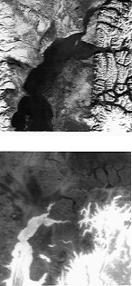
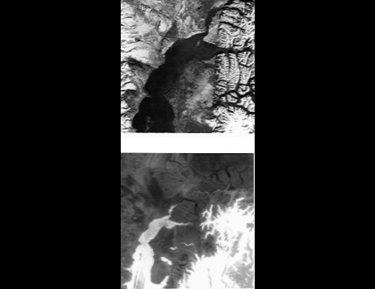
Image Caption cont: The picture on the right is a thermal infrared scanner image on a somewhat larger scale from a weather satellite. The Pacific Ocean is the warmest and brightest object in the image, masked in places by higher and colder clouds. This image was taken in January, and Cook Inlet, especially Knik Arm, is partially covered with sea ice. Three lakes remain unfrozen on the Kenai Peninsula. Otherwise, the image, recorded during a severe cold spell, shows clearly the inversions that make the valley bottoms around Cook Inlet colder (darker) than all but the highest of the uplands.