Measuring the Earth's Changing Shape
Unlikely though it may sound, the most important discoveries ever made about the surface of planet Earth almost coincided with the beginning of the space age without the two being directly related. In the late 1950s and early 1960s, the first positive evidence was found that the continents were not held in place, but wandered about like blobs of fat floating in a pan of hot water. These discoveries were made not from space, but at the bottoms of the oceans.
Rock samples collected from deep sea soundings showed conclusively that material from the earth's mantle was being extruded onto ocean floors at ridges, and that the whole ocean floor was then forced away from the ridges at an inch or two per year by material crowding in from behind, and absorbed back into the earth at oceanic trenches. The analogy of a pan of boiling water is a good one. Water molecules are heated at the bottom of the pan near the center, then rise to the surface, cool, and sink again near the rim. The process continues in the form of a gyre known as a convection cell, the surface of which carves the globs of fat into miniature "continents."
Even though the space age and the new discoveries in global tectonics are maturing together, only the most far-sighted could have foreseen that, in a mere two decades, they would become so interwoven.
There are several ways by which changes in.the earth's shape can be measured from space. The process of "continental drift" (an old expression, but a good one) is exceedingly slow in terms of, say, a human life span, and motions are very small in comparison to the size of the earth. But the length of a radio wave or a light wave is also very small, and these are the units by which the changes are measured.
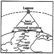
At present, three methods are being used to make global measurements from space. The first uses the moon, on which astronauts placed "corner reflectors" which bounce back laser beams transmitted from observatories on earth (of course, these measurements also serve to study the moon's shape and orbit).
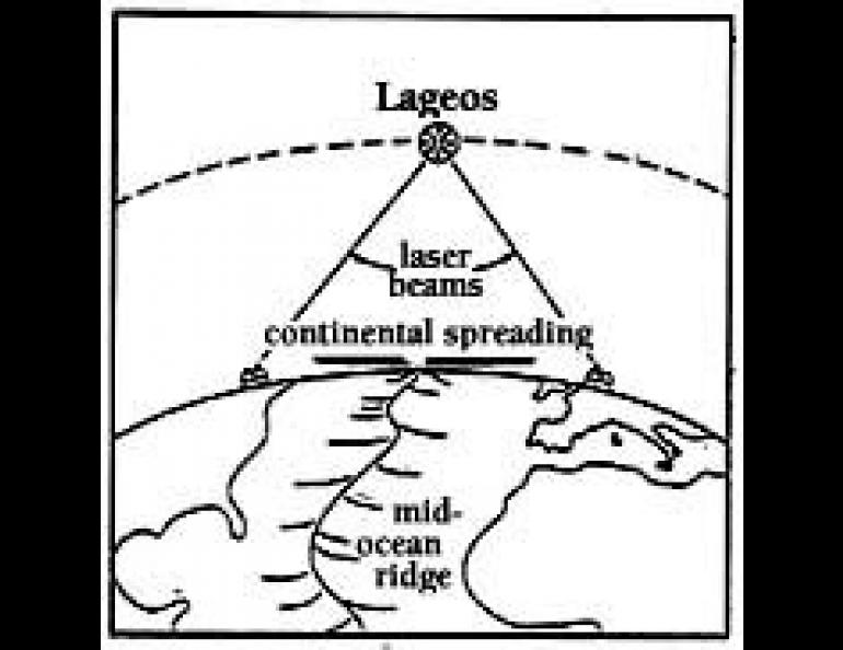
The second method utilizes the satellite Lageos (for Laser Geodynamics Satellite) which was placed into an extremely stable,. well known orbit in 1976. Lageos is a two-foot sphere which is covered with corner reflectors. It is completely passive and serves only to bounce back the laser beams aimed at it. The distance to corner reflectors can be measured to within fractions of a wavelength of light by comparing how much the wave has shifted during the time it took to travel to the reflector and back. If the reflector were right next to the laser, the original wave would be in perfect synchronization with the wave reflected back. But the further away the reflector is, the more out of phase the returning light wave becomes. Peaks and troughs of the two wave trains do not then coincide, and the amount of overlap provides a measure of distance to the reflector.
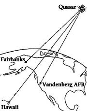
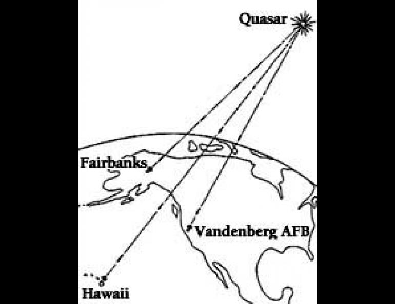
The third way by which changes in the earth's shape are being measured from space is through the use of objects in deep space such as beacons by which to measure the distance between two objects on earth.
The strong radio wave sources known as quasars, which are believed to lie near the limits of the universe, are utilized for this purpose. This is not really so different from using lasers light waves and radio waves; they are merely different wavelengths in the electromagnetic spectrum. Radio signals from quasars vary irregularly, permitting particular parts of the signal to be identified and recorded simultaneously by two antennas which may be thousands of miles apart.
Atomic clocks which are stable to within one-billionth of a second per day, provide accurate times for portions of the signals to be "marked." The difference in arrival times of the marked segments of the two antennae is then used to determine the distance between them.
In Alaska, one permanent "listening" station for quasars is Gilmore Creek, the National Oceanic and Atmospheric Administration's tracking facility north of Fairbanks. Portable stations are operated periodically at other sites around the state, including Nome, Kodiak, Sourdough, Yakataga and Sand Point. These are tied into a wider network which includes stations in California, Hawaii, Canada and on Kwajalein Island in the South Pacific. For those who are interested, measurements have been made using quasars that show that the distance between the Nome and Gilmore Creek stations, for example, is 848,263.316 meters.That represents precision to within about half the thickness of a pencil lead, although repeated measurements will probably yield a scatter of values over several times that amount.
The bottom line to all this is that estimates of the rate of continental drift made by geophysicists without the benefit of space observations were remarkably accurate. For instance, Lageos observations show that the Pacific basin is moving to the northwest with respect to North America at the rate of about an inch and half per year. At the same time, the South Pacific is overtaking Australia from.the east at almost three inches per year. These are very close to earlier estimates based on the geological record. In other words, with space age technology, we are now learning, within the span of a few years, information that previously could be obtained only from geologic evidence that required millions of years to accumulate.